Archive for the Environmental Journalism Category

F8 Magazine – Featured Photographer

Posted in Adventure, Cancer, Colorado, Conservation, Environmental Journalism, Europe, Glacier, Photography, Trekking, Utah, Wilderness with tags , , , , , , , , , , , , , , , , , , , , , , on February 10, 2011 by chriscasephoto

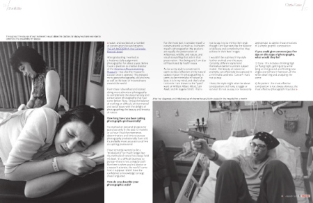
I was contacted by F8 Magazine (an online photo magazine from Spain) late in 2010; they had found my work on Photoshelter and had perused my online portfolio and liked what they saw. So, they sent me some interview questions and asked for some of my favorite images and they put together a great spread in their second issue, just released in mid-February. Following are the layout and interview, but to see it all as it was intended to be seen, see the online magazine.

Hi Chris. Tell us a little bit about yourself.
I was born in Connecticut and grew up along the New England coast. I received a degree in neuroscience and worked for a number of years as a researcher in that field, first with patients with schizophrenia and then, literally, slicing monkey brains in a study of Parkinson’s disease. It was in that basement laboratory, under fluorescent lights, slicing frozen monkey brains eight hours a day, that I decided to pursue photography. It was not a terribly difficult choice. Of course, it has been a bit more difficult to succeed as a photographer than it was to take that first step and apply to graduate school for photography.

F8 Magazine

What or who got you started in photography? Is there any formal training in your background?
I’m not entirely sure what my initial attachment to photography was. In college I was interested in art and photography, as a way to balance my life while studying neuroscience. I ended up with a second degree in art and art history, of which two photography classes were a requirement. The professor I had for that initial photography class would become a great mentor, friend, and influence on my work.

But, most important to my development as a visual storyteller, and the most influential and life-changing work I’ve been a part of came from one of my first “projects.” While I was still working in the neuroscience field, I was in a relationship with someone who was diagnosed with leukemia. I immediately started documenting her life, treatment, and recovery, and our life together. I had only known her for eight weeks, and we spent the next four years together. The camera became a part of both of our lives, as much a method for dealing with the circumstances as it was a tool for documenting our shared experience; I documented as many intimate moments as I could. See a gallery of images here. It wasn’t until later that I discovered Eugene Richards’ work “Exploding Into Life.”

Still, time spent slicing brains ultimately led me to seek a degree in the field. That’s how I ended up at the University of Texas at Austin for their master’s program in photojournalism. There, I became devoted to environmental issues, particularly water, and worked on a number of conservation-focused projects.

After graduating, I worked as a freelance daily assignment photographer for about a year, before I took a position as creative director of the American Mountaineering Museum. I was also the museum’s curator once it opened. This exposed me to great photography, old and new, as well as the feats of mountaineers around the world.

From there I diversified and started doing more adventure photography to complement the documentary and conservation photography that had come before. Now, I enjoy the balance of working on difficult, environmental and social issues with the delight of photographing the beauty and ferocity of nature.

F8 Magazine

How long have you been taking photographs professionally?
I’ve worked on personal projects for years, but only in the past 12 months or so have I had the experience, determination, and time to pursue photography professionally. Even still, it’s probably more accurate to call me an aspiring professional. I have certainly wanted to be a “professional” for much longer, but my methodical nature has always held me back. It’s a difficult business to pursue–there is not a singular path like there is when you’re a doctor or a research scientist, the world I came from. I suppose I didn’t have the confidence or knowledge to forge ahead unguided.

How do you describe your photographic style?
For the most part, I consider myself a conservationist as much as I consider myself a photographer. My passions are equally the preservation of wilderness, wildlife, and nature, and visual storytelling that aids in that preservation. That being said, I am also still fascinated by health issues.

As far as my style is concerned, it seems to be a reflection of the natural subject matter I’m photographing. It seems to be minimalist in nature; at least, it is in my mind, and that’s what I strive for. I am drawn to the “quiet” work of William Albert Allard, Sam Abell, and W. Eugene Smith. That is not to say I try to mimic their style, though I am fascinated by the balance of delicacy and complexity that they achieve in their best images.

I wouldn’t be surprised if my style further evolved over the years. Certainly, different styles lend themselves better to certain subject matter. The beauty of nature, for example, can effectively be captured in a minimalist aesthetic. Cancer? That’s not as easy. There, the style might often be about juxtaposition and irony, struggle or survival. It’s not as easy, nor necessarily appropriate, to depict those emotions in a simple, graphic composition.

F8 Magazine

If you could give someone just five tips on this type of photography, what would they be?
1) Stare. This includes climbing high (or flying high), getting dirty while lying on the ground, and finding new angles everywhere in between, all the while observing and analyzing the scene.

2) Be patient. The most effective composition is not always obvious; the most effective photograph may take you 100 attempts to get exactly what you want. Don’t settle for anything less.

3) Be intelligent and thoughtful and respectful. Know your subject before you begin photographing, then allow the subject to lead you to what you should be learning more about. Be open minded so that new observations are put to good use in framing the story, rather than ignored because of any preconceived notions of what the story “should” be that you might have started with.

4) Experiment. Forget what you learned and try a new approach. Perhaps that’s creating an abstract world from something familiar, or distilling something highly complex to a graphic essence.

5) Stare some more. Find something better, or different, or unique, and know that you’re the only one that is creating the work, and the audience’s reaction to it is often unpredictable. Don’t make photographs that you think people will like; make photographs you like.

F8 Magazine

You are the editor and director of photography and design of Trail & Timberline magazine, published by the Colorado Mountain Club since 1918. Tell us, what is the focus of the magazine and how does it expand your ability as a photographer?
Trail & Timberline is a reflection of the Colorado Mountain Club, so its focus is conservation, education, and recreation, specifically related to Colorado’s mountains and mountaineering. Ideally, there is a mixture of each of those things in every issue (see some samples here).

I am a staff of one: editor, photographer, writer, and designer. Besides being very rewarding, challenging, and fun, working on all parts of the magazine helps me to understand the packaging of photography and visual stories, which in turn makes me think about these things when I’m in the field. It makes me a better photographer, and a better journalist. Of course, there are certainly times when I’d like to be collaborating with a dynamic and creative staff; I’d like the pressure that would come with delivering for a photo editor. But, I have the challenge of balancing all of those roles simultaneously. It’s a very satisfying feeling when it all comes together.

F8 Magazine

What are the typical preparations that need to be made before a shoot? (Both in terms of camera equipment and researching the location itself / weather etc.)
Nothing beats spending time with your subject, whether that subject is a person or a place.

As far as equipment is concerned, I’m a minimalist. I carry three lenses most of the time; I never use a flash. I am often trying to capture nature, so I feel as if introducing unnatural light would be absurd. If my battery is charged, then I am ready to go.

As far as adventure photography is concerned, there are certain precautions that I take, particularly in the winter when there is the risk of avalanche. Checking the avalanche data regularly throughout the winter is just a habit now. Thankfully, in Colorado there is a great website for this.

Likewise, weather is a concern in slot canyons. If there is any chance of rain, it’s not a wise idea to be wandering around in a giant funnel of rock. Having patience and waiting for stable conditions is just a part of exploring that world.

F8 Magazine

Will you ever feel like your work is completed?
That is a very difficult question to answer. Certainly, there are times when I feel like nothing can change the environmental catastrophes that seem to be raging around us. There are times when I feel like all of my efforts to tell visual stories won’t change the overwhelming momentum that they’re up against.

So, I suppose my answer would be “no.” I don’t think my work will ever be completed because I don’t think there will be a time when conservation doesn’t need the help of story telling. In a more general sense, my work as a story teller won’t be finished because there will always be stories to tell.

I just hope that along the way I can contribute to the preservation of a particular landscape, or change the behavior of people, or excite and inspire someone through my work.

F8 Magazine

What’s the most inspiring location you’ve visited so far?
I seem to be fascinated by any new place I go, and tend to be inspired everywhere I go, whether that’s a delicate shortgrass prairie on the Great Plains, a lush estuary on the Gulf Coast of Texas, or the jagged drama of the Swiss Alps. That being said, I can’t remember ever being as awestruck as when I recently trekked the length of the Haute Route, from Chamonix, France, to Zermatt, Switzerland. It’s not the most remote area, or the least populated, but there’s no denying that it’s gorgeous (see images from the Haute Route).

But perhaps the most inspiring place I’ve been is southern Utah. It’s like no place else on Earth. I’ve been countless times to explore the canyons, formations, alcoves, ancient dwellings, mesas, and mountains, and I’ve never been disappointed (see images of Utah). It is always inspiring to be present among such a unique landscape, with a palpable feeling of quiet around any corner. The forms, the shapes, the experiences you can only have in a place where time is evident in every rock around you, and you are perceptibly small in a vast spread of geologic time. As may be evident, it helps me to think and makes me philosophical. And the scenery never ceases to amaze me, or inspire me.

Unfortunately, much of this iconic landscape remains unprotected. And the threats to it only increase with time. This is especially true of places like White Canyon. To think that places like this exist nowhere else on Earth, yet remain unprotected from vehicles, development, oil and gas extraction, is alarming. I couldn’t imagine a world without them in their pristine state. That’s why I work with organizations like the Southern Utah Wilderness Alliance to help them educate people to the threats these iconic landscapes face.

What kind of impression do you hope to leave upon others who see your photographs?
I believe all I can hope to do is make people think. A photograph doesn’t bring about change by itself. A person has to use that photograph, or be used by that photograph, in order for action to take place. And the first action is always thought.

F8 Magazine

Hope and Peace and Pain – Part 5

Posted in Adventure, Environmental Journalism, Europe, Glacier, Photography, Trekking, Wilderness with tags , , , , , , , , , , , , , , on January 4, 2011 by chriscasephoto

This is the fifth and final installment of an article that first appeared in Trail & Timberline magazine. Read the first installment here. Read the second installment here. Read the third installment here. Read the fourth installment here.

The Walker’s Haute Route takes trekkers through the alps from Chamonix, France, to Zermatt, Switzerland.

See a gallery of photos from the route here.

_______________________________________

Day 12 | St. Niklaus to Europa Hut
We start our final push up the Mattertal valley, toward the iconic Matterhorn, with another intrepid refusal. While many people take the bus to the village of Gasenried to begin the Europaweg (the trail that runs up-valley high on the shoulder of the Mattertal), we decide our young minds, legs, and feet can carry us more satisfactorily. So we sweat our way up, rising high above the clutter of arteries, both road and rail, that squeeze through the neck of this glacial gorge.

With the Bernese Alps above Interlacken now at our backs, we rise higher still and gain immaculate views of glaciers, peaks, rivulets, waterfalls, rockslides, clinging hamlets, delicate meadows, and the steep and dramatic topography that Switzerland is so famous for. And the trail slices right through it all.

Europaweg

Well, soon after Brianna begins to question the trail, the “weg” (way) in Europaweg, as the way seems to be washed away by rock slides, avalanche, and glacial detritus. Now and again, we pass through exposed sections with signs that, when translated, read, “Run, but do so slowly” and frail-looking bridges with warning signs that actually say “Not swing!” It makes for our longest day. But, it is perhaps the most beautiful day, as well, with glimpses of the crooked finger that is the Matterhorn, and constant views of the imposing, monstrous Weisshorn and the many lesser, but no less interesting, peaks and glaciers that defy gravity, like cookie batter clinging to tree bark.

The heights, the precarious ledges, our dashes across sheer, sand-slope washes, make for a mentally taxing, physically demanding day, and the elevation gain of 5,200 feet satisfies us all the more. It’s official: We’re both bloody masochists.

Finally, we arrive at the Europahütte knowing we sleep on the floor. When they run out of room in the dorm beds, they open up the dining room for extras. And, tonight, we’re extra.

Over dinner, as if our brains hadn’t been stressed enough, we have a remarkable, but mind-numbing conversation with Florian (a native of nearby St. Niklaus) and Stefanie (from Strasbourg, France) in a dizzying combination of German, Schwyzerdütsch (the local dialect), French, and English, or “Freutsch” as I like to call it. Our heads hurt. Their heads hurt.

We drink beers, big and small, and Brianna finally drinks the glass bottle of wine that she bought in Zinal three days earlier!

Day 13 | Europa Hut to Zermatt
Could it be?! We had seen it the night before. We were told it was only three weeks old. With Florian’s binoculars I can see the prayer flags. And then, after dashing under an icy waterfall, we arrive at a brand new, Swiss-engineered, rockfall-defying, heart-palpitation-inducing, suspension bridge, the likes of which I have never seen before.

Strung between two rock precipices, over a filthy slope of crumbling stone and sand, it seems like an improvement over trying to cross this stretch of rockslide highway. And, it isn’t too bad, except for the part where you can look down to the chasm we are floating over and see the avalanche tunnel that has disintegrated under the crush of falling rock, presumably prompting the construction of this marvel of mountain trail enhancement.

It takes six and a half minutes of constant, steady walking to get across. I know, I have a video of the entire thing. A few deep breaths for Brianna and she’s ready for solid ground again.

Resting on the Europaweg

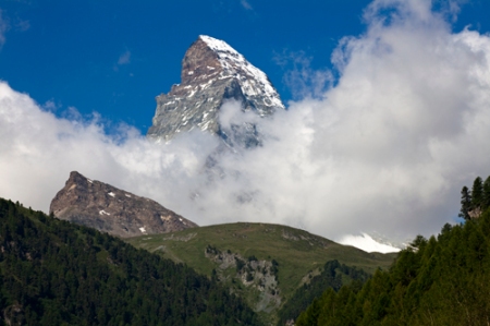
For a final day, we couldn’t be luckier with the weather, the temperatures, the scenery, or the company. We cruise much of the rest of the day with views of our new favorite mountain, the Matterhorn. We cannot take our eyes off it, with every step we see a new wrinkle, a better angle, a finer detail on its many weathered faces.

Did I say we were lucky? That is until we arrive at the Winkelmatten trail. On any other day, we’d be able to leisurely stroll on the partially paved trail and, in fact, there were families of smoking Dutch and baby-laden Italians doing just that alongside us. But now, oddly, they are doing all the passing.

Matterhorn

Twelve and a half days after originally feeling excruciating pain, Brianna’s knee finally decides to return to threat level nine. We limp arm in arm through the peaceful village of Winkelmatten, then wrestle through the scrum that is Zermatt proper during its summer heritage festival.

We calculate that camping and eating in this luxurious and posh village will be almost as expensive as staying in a hotel we already know, Hotel Bahnhof, and cooking dinner in their fabulous kitchen. We trade the bad luck of a busted knee for the good luck of claiming the last room for the night, and have ourselves pleasant dreams.

Vive Le Haute Route!

40,646 feet of elevation gain

38,852 feet of elevation loss

114.4 miles

13 days

11 passes

6 Snickers

4 new friends

3 walking sticks

2 feet + 2 feet

1 Matterhorn

0 chairlifts, buses, trains, or cars

The Power to Protect: Citizen Conservation – PART 2

Posted in Adventure, Colorado, Conservation, Environmental Journalism, Photography, Wilderness, Wildlife with tags , , , , , , , , , , , , , , on October 12, 2010 by chriscasephoto

Nose to the Ground
As a kid, Marty Colón spent his days studying tracks in the tacky sands of Lake Michigan’s shore. He would find a track, identify the animal that made it, then follow its path up and down the beach.

That’s a pretty great childhood.

Essentially, Marty is still following the tracks of his childhood. Now, however, he’s tracking mammals big and small and teaching others the rewards of observing the signs, scats, and tracks beneath their feet.

There are stories imprinted in the soil. While you’re sleeping, when you’re not around, when you’re at work in the city, animals are roaming the woods, riverbanks, and alpine tundra. If you never see these animals, it doesn’t mean they don’t exist—or that you can’t unravel the mystery of their behavior.

Tracking offers an extension to what we see. With a bit of patience, an investigative method, and dirt on your knees, you can figure out what animal it was that went down the trail before you.

Marty has been teaching tracking skills for 30 years. He’s honed his method to three simple steps. Follow them (and take a tracking class or two) and you will not only be able to follow the animal’s tracks, you’ll be able to see an entirely new world of behavior that wasn’t apparent before.

1) Collecting Track Level Evidence
As the name implies, track level evidence is on the ground—not in a book, and not in your brain. When you come across a track, be careful not to guess, thinking you are familiar with the print. Be careful not to exclude certain species based on your presumed familiarity with its habitat and range. When I took a class with Marty, we found a black bear track in Prospect Park. Yup, in the middle of Wheat Ridge.

There are four pieces of evidence that you will want to look for—and write down in a notebook. First, count the number of digits. In Colorado, that can be four, five, or two (technically, the ungulates—things like deer and elk—have a hoof made of two clouts).

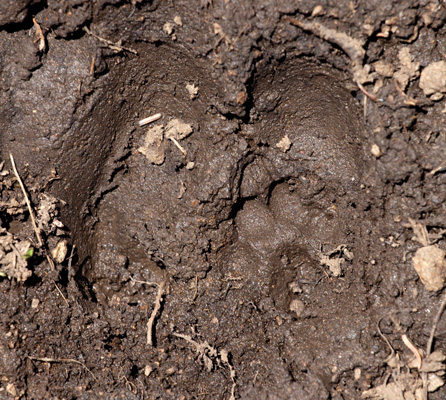
Herman Gulch Tracking

After you’ve determined the number of digits, you’ll want to decide whether they are long and slender like fingers, or short and stubby like your big toe. If you can see any claws, note whether they’ve made a fine point near the tip of the digit (indicative of claws that are curved at a 90-degre angle and good for climbing) or are a bit thicker (like a dog’s claws, which are your general purpose claw—not built exclusively for climbing or digging). If you see the indication of a long, thick claw that extends well beyond the end of the digit, you’ve probably found the track of a digger—things like skunks, badgers, and wolverines.

Finally, make note (in fact, make a sketch) of the shape of the interdigital pad, the surface that sits behind the digits—it can look heart-shaped, bean-shaped, and sometimes like the heel of a human.

2) Determining Family
If you know the number of digits in a track, you can start to hone in on the family of your animal. Four digits? It’s very likely to be from the dog, cat, or rabbit family. Or it could be from the rodent family, whose animals have four front digits and five in the rear.

Five digits? It will have to be from the raccoon, opossum, shrew, bear, or weasel family (things like wolverine, sea otter, badger, skunk, marten, and ferret). Again, rodents have five digits on their rear feet so you could have yourself a rodent track.

Two digits? That’s a bit easier; you’ve found a track from the deer family: bison, moose, elk, bighorn sheep, mountain goat, caribou, mule and white-tailed deer, or pronghorn.

If you know the structure and function of those digits, you can eliminate even further. Are they long, finger-like digits that would be good for grasping and climbing? Think of raccoons and squirrels. Are they short and blunt, general purpose toes? Think dogs, cats, and bears.

Next, the shape of the interdigital pad tells you even more. Based on it’s shape, you can further refine your search.

3) Determining Species
Now you’re ready to take the final step and unravel the mystery. Here, you can use a series of gross filters to eliminate species within each possible family. First, look at size. Using a tracking field guide, you can determine if the track is near in size to the average track for a particular species. Too big or too small and you can eliminate that animal from your list of suspects. Be sure not to measure claws—or overshoot your evidence. That is, don’t eliminate an animal unless you’re absolutely sure. In the end, you may not have enough evidence to narrow it down to only one species.

Marty’s guide of choice? Falcon Guide’s Scats and Tracks series. There’s one specific to the Rocky Mountains that’s small enough to carry each time you head into the outdoors.

Compound Track

Power in Numbers
Certainly, this brief overview isn’t enough to turn you into an expert tracker, or a citizen scientist. But we all possess what it takes to start as a citizen naturalist. And perhaps  this lesson will inspire you to learn more. With a bit of training and a sound method, the skill of tracking (and scat and sign identification) can make every landscape come alive in a new way.

Still, you may be thinking that these simple observations are just that: simple. But, over time and in large quantities, the information that citizens collect can tell us a lot about the changes taking place in a landscape and its viability as suitable habitat. No, they won’t replace raw data, scientific inquiry, or thorough research, but they can wholeheartedly supplement it. And they give us a role in preserving and protecting Colorado’s wild places and wild things. That’s quite a powerful feeling.

Read the first part of The Power to Protect: Citizen Conservation.

The Power to Protect: Citizen Conservation – PART 1

Posted in Adventure, Colorado, Conservation, Environmental Journalism, Photography, Wilderness, Wildlife with tags , , , , , , , , , , , , , , on September 29, 2010 by chriscasephoto

When you’re out hiking, do you ever see wildlife tracks? Ever see (or step in) elk scat? Chances are, you see them all the time. Ever roamed through a wildlife corridor? Hiked amongst the habitat of an endangered species? Chances are, you’ve probably done this, too, whether you’ve known it or not.

Now, what if you could put your passion for the outdoors to good use for Colorado’s roaming wild things? All it takes is something you’ve already got: two eyes and two feet.

Everyday citizens, especially those who often find themselves out on the trails of our state, have the power to make a difference in protecting our land, and the animals who call it home. The success of many conservation efforts is based on being able to document and monitor the threats within a particular landscape, and gauge any changes that result from the efforts. Increasingly, conservation professionals are looking to volunteers as important components to successful conservation programs.

There are a wide range of skill sets and training requirements for conservation volunteers, depending on the needs of the program. Some of these have specialized technical classes in areas like wildlife tracking or habitat and species identification; you might hear this referred to as “citizen science.”

However, one of the most underutilized volunteer skills is the simple power of observation. Citizen naturalist programs that rely more on this natural world experience and less on the specialized training of citizen science are equally powerful for furthering conservation. Either way, anyone who spends time in the outdoors can benefit from knowing more about what they’re seeing around them. And Colorado—and its wildlife—will benefit, too.

Analyzing animal tracks

Finding Signs
Each place we hike in is a bit different, in terms of the species of wildlife we might see, the intended use of the land, the condition it is in, and the threats it may be facing—or may face in the future. Perhaps the corridor falls on National Forest land, and is managed for multiple uses like recreation and timber production. Perhaps the area is known to be prime habitat for a threatened or endangered species.

By keeping a few simple questions in mind when you’re hiking, you’ll be able to help scientists and land managers better understand the landscape and how wildlife use the area. If the corridor happens to be near a major highway, like Herman Gulch, then your visit will help you to understand the importance of landscape connectivity.

Keep in mind questions that help tell the overall story of the conditions and suitability of the area for wildlife: Which animals did you observe and where?

People are not the only ones that think with their stomachs. How about food for wildlife? Did you see plants for foraging or prey species?

Water is usually an important feature of a wildlife corridor. Did you see good sources of flowing water or perhaps snow pack in the hills?

The climate of Colorado is changing; colder, longer winters used to be a natural control of the native bark beetles in our forests. Did you see large stands of trees with reddish-orange needles, or stands of dead trees?

The answers to these questions will indicate how the area’s multiple uses are being managed, and how habitat fragmentation can affect various wildlife species.

So, what do you do with this information once you’ve collected it? Well, always be sure to write things down and photograph or video animals, tracks, scat, rubbings, markings, and any other signs of wildlife behavior, corridor conditions, and impacts.

Then, you can turn to that great database in the sky: the internet. In fact, organizations like Witness for Wildlife are designed to help people document and record their observations; they even have field guides for known wildlife corridors online so that you can download them before you make your visit.

What are they hoping to collect? Not only are these organizations interested in what you’ve seen—everything from the animals you may have been lucky enough to see, to the conditions of the habitat—but they also want to know what your experience was like. Did the practice of observation change your perspective of corridor connectivity? Did you see solutions to any of the threats that might have existed?

You can find downloadable field guides to corridors across Colorado (and the country), learn more about corridor hikes in your area, and input your own observations at www.witnessforwildlife.org.

Of course, there’s always a next step. This one, however, is certainly not for everyone. But, if you feel like taking your powers of observation to a whole new level, with a little training you can turn your hikes into sleuthing excursions in the outdoors, a fusion of detective work, scientific inquiry, and, of course, walking in the woods.

Read the second part of The Power to Protect: Citizen Conservation.

Back home in Colorado

Posted in Colorado, Environmental Journalism, Photography, Wilderness, Wildlife with tags , , , , , , , , , , , , , , , , on September 14, 2010 by chriscasephoto

I recently traveled through the Alps on foot and, as you would imagine, it was absolutely gorgeous. Panoramas that could make you trip, gnarled unions of fragmenting glaciers and scaly rock, glowing green grasses. But, there was something missing.

Wildlife.

Yes, there was the occasional marmot or chamois. But, that was it. The only animal I saw time and time again was, of course, the cow. These cows may have looked a bit disreputable, but they weren’t wild.

So when I returned to Colorado, it was rewarding to begin work on this special issue of the magazine. It quickly reminded me of all the incredible species of animal that call Colorado home, some of which can’t be found anywhere else in the world, and some of which face threats that put their entire existence into question.

These animals could use our help. They aren’t as resilient as we humans seem to be to the onslaught of new roads and hazards in our state. While most of us probably daydream about roaming free, their very survival depends on it.

And they make Colorado an enviable place to live. They make every trip into the mountains an opportunity to be surprised, or astonished, by their very presence.

The next time you’re out roaming free, think of them. They want the same thing you do.

See more photography at www.chriscasephoto.com.

San Juan-Canyonlands Proposed Wilderness

Posted in Adventure, Environmental Journalism, Photography, Utah, Wilderness with tags , , , , , , , , , , , , , , , , , , , , , , , , , , , , , , , , , , , , , , on May 21, 2010 by chriscasephoto

I’d do most anything to help protect Southern Utah. It’s serpentine canyons, abstract geology, and rich archaeological holdings are hard to surpass. So, when I approached the Southern Utah Wilderness Alliance about how I could help their cause to establish new wilderness areas in and around Canyonlands National Park and San Juan County, I was delighted to know they were looking for images from some of the most threatened and most incredible portions of the proposed wilderness area. One of them was White Canyon. So I set out to immerse myself in its phenomenal twists, slots, and pools, if only for a week.

When I returned from my brief excursion, I immediately contacted SUWA and let them know I would be happy to donate some of my images for their work. “That’s excellent,” they said. “Can we download some tonight? We’re meeting with a Senator tomorrow to make a presentation to him on our wilderness proposal. Your images would really help us make the case for its protection.” It was an incredible feeling, actually, knowing that my work would play even a small role in the area’s eternal protection by passing before the eyes of someone who has the power to sponsor such a bill in Congress. “By all means,” I said. “Take as many images as you need.” Let’s hope that the wilderness proposal soon becomes wilderness reality.

Entering the narrows of White Canyon, Utah, part of the San Juan-Canyonlands proposed wilderness area.

White Canyon makes a gorgeous, serpentine cut through Cedar Mesa, near Glen Canyon National Recreation Area. It lies at the heart of the proposed Glen Canyon Wilderness, where the vast expanse of Paleozoic-era sandstone known as Nokai Dome eases its way to the upper reaches of Lake Powell in the Glen Canyon National Recreation Area. This region also includes the soaring Wingate Cliffs of the Red Rock Plateau, Mancos Mesa, Moqui Canyon with its meandering stream, Red Canyon, and the serpentine side canyons of White Canyon. This is one of the most remote regions of the state, but it lacks protection and is threatened by increasing ORV use.

It is all part of the San Juan-Canyonlands region of Southeastern Utah is one of the most iconic landscapes recommended for protection in America’s Red Rock Wilderness Act, boasting dramatic geologic features wrought by elemental forces, as well as internationally significant cultural sites of the Ancestral Puebloans and the Mormon Pioneers. Adorned with buttes and arches, vast stretches of slickrock deposited over 250 million years ago, ancient pinyon-juniper forests and an artist’s pallet of red-hued sandstone, the San Juan-Canyonlands region has inspired explorers since the days of John Wesley Powell, and its wonders represent some of the greatest unprotected wilderness in the country.

See more photography at www.chriscasephoto.com.

As Thoughtful As Zahniser

Posted in Colorado, Environmental Journalism, Wilderness with tags , , , , , , , , , , , , , , on May 5, 2010 by chriscasephoto

This article first appeared in Trail & Timberline magazine, in an issue devoted entirely to the subject of wilderness. To see the entire magazine, including the below article, CLICK HERE.
____________________________

“The wilderness…is indeed intensely human, and perhaps after all it is the human association with the wilderness—so intense, so remote from the artificial distractions of all our machines and contrivances—that gives to these wildlands their supreme value and gives to their preservation for still other human beings the ultimate justification and imperative.”
– Howard Zahniser

We could learn a lot from Howard Zahniser, and not just about the value of wilderness. His name is not often mentioned alongside the likes of Muir and Leopold, but his legacy may be more profound. Without the Wilderness Act that he authored—uniting the most wild of places into a system of wilderness reserves—the world might still be grappling with “a sequence of overlapping emergencies, threats, and defense campaigns,” the battleground against which he rallied in 1951.

“The wilderness that has come to us from the eternity of the past we have the boldness to project into the eternity of the future,” he wrote.

But to unite wilderness, he first had to unite opposing forces. His relentless promotion and justification for a wilderness bill was surpassed in significance only by his enduring pursuit of the broadest possible consensus around the bill. This may have been Zahniser’s greatest success. His dream was not to achieve any type of protection, but to forge a method of permanence, something he reasoned could only be achieved with respect and consideration for views unlike his own.

He searched for the virtues in the arguments of those who opposed wilderness, attempted to meet their objections with reason, and respected the integrity and sincerity of those on the other side of the wilderness line.

He did this not for himself but for wilderness. He genuinely yearned to reach some agreement whereby his interests and the interests of the opposition could be reconciled, for the benefit of wild places, wild things, and wild ideas.

It was his cloak of humility.

“Working to preserve in perpetuity is a great inspiration.
 We are not fighting a rear-guard action, we are facing a frontier.
 We are not slowing down a force that inevitably will destroy all the wilderness there is. We are generating another force, never to be wholly spent, that, renewed generation after generation, will be always effective in preserving wilderness.
 We are not fighting progress. We are making it.
We are not dealing with a vanishing wilderness.
 We are working for a wilderness forever.”

We want our Colorado to remain wild, like he wanted his wilderness to last forever. If you have no wild spaces in which to roam free, then how will you find yourself? If you can’t find calm in the singular tranquility of an alpine meadow, then what do you call serenity? If your views are muddied brown or your quiet shattered, then how will you ever think clearly?

Let us strive to be as thoughtful as Zahniser in whatever we do: meet opposition with wisdom, consider the opposition with admiration, stand true to our convictions and keep Colorado wild.

See more photography at www.chriscasephoto.com.

What’s Wilderness Worth?

Posted in Adventure, Colorado, Economics, Environmental Journalism, Photography, Wilderness with tags , , , , , , , , , , , , , , , , , , , , , , , , , , , , , , , on March 14, 2010 by chriscasephoto

This article first appeared in Trail & Timberline magazine, in an issue devoted entirely to the subject of wilderness. To see the entire magazine, including the below article, CLICK HERE.

____________________________

What’s wilderness worth? Listen to the eloquence of John Muir and Wallace Stegner; feel the passion of David Brower and study the methodical ethic of Aldo Leopold. Their words define wilderness. Yet, their thoughts never amounted to a sum value. Worth can—and in the case of wilderness, should—mean so much more.

Now, however, in an era of caustic debate falsely pitting land against man—landscape preservation against economic salvation—the answer to the question of what wilderness is worth has taken on new power.

“People opposed to wilderness began raising the economic question,” says John Loomis, a professor of agricultural and resource economics at Colorado State University. “Mining, timber, livestock grazing, even the chamber of commerce will say, ‘Oh my god, these are elitists that want wilderness.’”

So, after Loomis and other economists considered the question, we have wilderness economics—and can place a value on protected places, if we so feel the need.

Most of us know better than to rely on private enterprise to tell us the value—both tangible and intangible—of wilderness. The argument placed forth by extractive industries—that removal is the only use that yields wealth—is an epic lie. Theirs is a penchant for converting the natural wealth contained in the nation’s pristine forests, deserts, canyons, and mesas into a fleeting boon of corporate profit. It never lasts. Indeed, it can’t last.

Ultimately, the choice is not, and never has been, between mining (and money) and preservation (and poverty).

John Muir used powerful words to express the value of Yosemite Valley. Now, words aren't enough. Wilderness preservation has been positioned by some as the opponent of economy salvation, albeit falsely. Still,wilderness economics begs the question: How much would you pay to see a place like Yosemite last for eternity? How much would you pay to make sure your grandchild had a chance to witness mists rise from the valley floor?

As many people are now realizing— politicians, boards of tourism, and county commissioners alike—wilderness means money, too. And wilderness lasts.

As many of the early wilderness proponents—trained scientists—knew, wilderness protection was about far more than recreation. “There is economic value just by preserving it,” Loomis says, referring to those less tangible benefits that have for so long been ignored. “Economic valuation provides some balance to the environment versus people dichotomy, which is a false comparison.”

But why has it taken so long for people to realize the sum value of wilderness? It may have to do with the complexity of economic valuation.

We can all see (and many of us take part in) the direct use benefits: things like hiking and hunting. Furthermore, the science community needs wilderness as a baseline for research and education. We all benefit from wilderness’ capacity to improve the resources most precious for life: air and water. These and other ecosystem services, as they are known, continue to gain prominence in the grand scheme of land protection, as we learn more about the benefits of carbon storage, nutrient cycling, and waste treatment provided by wilderness. Still, these things only constitute a portion of the total value of wilderness and wild landscapes.

The difficulty in understanding and calculating the sum value comes from things economists call passive-use values. They’re often broken into three categories: option values, bequest values, and existence values. The option value is akin to an insurance policy: people are willing to pay for more than their expected recreation benefits to maintain the option—for themselves or for their children—of visiting wildlands in the future. Similarly, the bequest value of wilderness protection represents what we would be willing to pay to bequest wildlands to our kids. Hardest to grasp, perhaps, is existence value, the notion that there is a psychological value a person enjoys from just knowing that a wilderness exists—regardless of whether the person will ever visit an area.

Politicians have tended to ignore the wilderness economics numbers. Preferring to cater to extractive priorities, they have chosen to view profit dollars through the short-term lens—that which is present and understandable—rather than employing more complex arithmetic to determine the economic value of a place over generations.

Yet, the figures for simple recreation—something that is tangible and profit-based—are stunning. In 1995, U.S. Forest Service economists measured the agency’s holdings and found that national forests generated $125 billion a year in economic activity. An astounding 75 percent of that figure was based on recreation economy. Timber and mining, by contrast, amounted to 15 percent. By 1995, it had become all too apparent that recreation, and not timber, was the Forest Service’s main product.

Furthermore, recently developed economic models have shown that public lands benefit more from quiet recreation—the hunting, fishing, hiking, and camping that take place so often in wilderness—than from motorized recreation. In Colorado’s Arapaho and Roosevelt national forests, for example, nonmotorized recreation provided 1,228 jobs and $37.8 million in income, compared with 244 jobs and $11.7 million for motorized recreation.

So, what does this all mean for a place like Colorado?

No case study may be more applicable than Kane County, Utah, which lies about 210 miles south of Salt Lake City. That’s because Kane County, home to much of the Grand Staircase–Escalante National Monument, was once the site of one of Utah’s most intense wilderness battles. It started in 1996, when the Clinton administration designated the 1.7 million-acre monument. That made Bill Clinton in Kane County about as popular as George Bush in Berkeley.

Alarmist predictions of economic disaster coursed through the small town and county seat of Kanab after plans to open a coal mine on the monument’s grassy Kaiparowits Plateau were halted by the designation. Instead of visions of boom, there were omens of bust.

Contrary to the residents’ worst fears, the bust never came. Instead, economic findings suggest that Kane County began to thrive. A comparison of data from the four years prior to the monument’s creation (1992–1996) with data from the four years after showed that the unemployment rate in the county dropped by more than half, while labor income rose faster than it had in the pre-monument period. Per-job earnings, which fell 7 percent before the monument, rose 13 percent after it was created. Property values rose significantly, too (after seeing a decline in years leading up to the designation). And, on Main Street, the average wage per job went up.

With the fortunes of the county hitched to the well-being of the mining industry and, therefore, at the mercy of globally determined price trends, Kane County could have suffered a roller coaster economic ride.

Instead, there was a path to sustainable growth. It wasn’t from a short-term influx of coal mining revenues. Word migrated that the area had a new monument. Some started visiting; others moved their businesses to Kanab, population 4,500, or decided to retire in Kane County.

An influx of retirees spurred growth in health-care jobs. Recreation boomed, of course. And, services that cater to the traveler grew, too.

Best of all, the landscape that drew all of this attention is never going to pack up and leave the area.

It, like all federally designated wilderness areas, lives on like the words of Muir, Stegner, Brower, and Leopold: forever.

See more photography at www.chriscasephoto.com.

The Next Chemical X? – Part 2

Posted in Chemistry, Environmental Journalism with tags , , , , , , , , on February 4, 2010 by chriscasephoto

THE NEXT CHEMICAL X? – PART 2
Polybrominated Diphenyl Ethers in a Flame Retardant World

Continued from here.

PBDEs—sometimes referred to as brominated flame retardants—were discovered and first used in the late 1970s. For the past 30 years, in increasing amounts, these flame retardants have been applied to most electronic appliances, computers, upholstery, carpet, carpet padding, lighting, wiring, building materials, furniture and industrial paint.  Some 149 million pounds of PBDEs were used in the manufacture of goods in North America in 2001. That equals fifty percent of the world’s use.

Every year, fire kills more than 3,000 people, injures 20,000 more, and results in over $11 billion in property damage in the United States alone, according to the National Fire Protection Association.  Still, because of laws requiring the presence of flame retardant chemicals in many industrial and consumer products—because of chemicals such as PBDEs—these numbers are greatly reduced from 25 years ago.  PBDEs have saved lives, prevented harm, and reduced the economic cost of fires.

Now, the requisite harmful side effects of PBDE – that which would secure it as the successor of the chemical X crown – are slowly being exposed.  Though the toxic effects of PBDEs are increasingly recognized, as we shall see, they have not yet been proven to directly lead to illness in humans.  Some varieties of PBDEs have been banned; some are scheduled to be banned.  Others continue to be manufactured.  Chemical X—today it is PBDE—has found its way into our environment, again.

For the past 20 years, scientists have been slowly recognizing an alarming rise in PBDE levels in humans, in wildlife, and in soils around the world.

“Everyone we’ve tested is exposed.  And the levels go from high to very high in the United States,” says Dr. Arnold Schecter, a researcher at the University of Texas Health Science Center in Dallas.

PBDE Pathway

In 2003, Dr. Schecter and his colleagues analyzed the levels of PBDEs in human breast milk samples taken from a milk bank in Austin, Texas and a community health center in Dallas, Texas.  Their findings raised concern among the scientists: the levels of PBDE constituents measured in their samples were similar to previous levels found in blood, but were 10 to 100 times greater than breast milk levels previously found in European studies.  Still, the question remained just how the general population was being exposed to these chemicals, and how the intake of these compounds was taking place.

In their most recent study, Dr. Schecter and colleagues sought to answer that very question.  They worked from the hypothesis that PBDEs, like their cousins PCBs, accumulate in humans through the intake of foods with high animal fat content.  Both chemicals are known to be fat-soluble, which would lead them to be absorbed by fatty tissue. Studying the levels of PBDEs in foods taken directly from supermarket shelves in Dallas, Texas, their findings indicate that food may be a major route of intake for these toxic compounds.

Samples of the grocery stores’ fish, pork, duck, turkey, cheese, butter, milk, ice cream, and eggs were tainted with PBDEs.  Only non-fat milk was clean.  In total, 31 of the 32 samples of common and name-brand groceries taken from the store were found to contain the compound, with fish products containing the highest amounts, followed by meats and dairy products.

“We’re finding that US blood and milk have the highest levels in the world; food has the highest level in the world.  Every person and every food product is contaminated,” Dr. Schecter says.

Could it be that Texas, and the surrounding regions, are simply prone to PBDE exposure? After all, the world’s two largest PBDE manufacturers, Great Lakes Chemical and Albermarle Chemical—producing 98% of all PBDE compounds—are located just north and east of the state.  Great Lakes Chemical, with its headquarters in Indianapolis, has several manufacturing facilities in Arkansas; Albermarle Chemical, headquartered in Baton Rouge, Louisiana, has facilities in Arkansas and in Houston.

The definitive answer is no; Texas is no more susceptible to PBDE contamination than any other part of the world.  And for proof of this we must travel half way around the globe.

Part 3 coming soon.

The Next Chemical X? – Part 1

Posted in Chemistry, Environmental Journalism with tags , , , , , , , , on January 23, 2010 by chriscasephoto

THE NEXT CHEMICAL X?
Polybrominated Diphenyl Ethers in a Flame Retardant World

Chemical X travels a predictable path.

Scientists find that, in the laboratory, this newly discovered chemical has effect A—an effect which will undoubtedly make some product shinier, or stretchier, or less combustible, or more resistant to cracking and, thus, will be considered of value to the progress and protection of human kind.

Another amazing Chemical X.

Chemical X is quickly and ubiquitously applied to consumer and industrial products to improve their quality. Soon, the world is filled with products, filled with chemical X.

Years later, epidemiologists and researchers discover that chemical X also has effects B, C, and D; first in mice; then in monkeys; then in humans. These effects, unfortunately, do not contribute to the progress of human kind; in fact, they are found to cause cancer, neurodevelopmental abnormalities, and liver malfunction.

Chemical X is finally banned from being manufactured or applied in developed countries.  Chemical X persists in the environment and its reputation as a savior slowly dwindles, as more and more information about its toxic properties is revealed, and more and more people show health effects. Just another Chemical X.

Unfortunately, this situation, though hypothetical, is just as easily recognized as being generic; many chemicals have become infamous for traveling this very path.

In the 1970s, chemical X was dichlorodiphenyltrichloroethane—DDT. It was developed as a pesticide and used effectively for many years to reduce malaria levels (by reducing mosquito population) before being banned from use in the United States in 1972. It was found to have persistent toxic properties: it is a probable human carcinogen, it damages the liver, temporarily damages the nervous system, and reduces reproductive success, according to the EPA. Notice the tense; for, although it hasn’t been used or produced in the US for more than 30 years, it can still be found in our environment and in people, even today. Other developing countries continue to use DDT in agricultural practices and in disease-control programs because of its effectiveness.

After DDT, chemical X became known as polychlorinated biphenyl—or PCB. It too is a persistent organic pollutant. More than 1.5 billion pounds of PCBs were manufactured in the United States before production ceased in 1977.  So toxic were they, that Congress implemented a “cradle to grave” management system specifically for PCBs.  Their toxic effects?  Cancer, of course.  They also include effects on the immune system (general suppression of the immune system among other things), reproductive system (reduced birth weight, reduced conception rate), nervous system (deficits in learning, short-term memory, and visual recognition), and endocrine system (alteration of thyroid hormone levels), among other health maladies.  They can still be found in soil and tissue samples around the world.

So, what will be the next chemical X?  What has come along to replace the DDTs and PCBs of the world?  Not surprisingly, the title of chemical X will stay in the family— polybrominated diphenyl ethers, PBDEs, are the toxicological and chemical cousins of the long-banned PCBs. They’ve already tread much of the way down the pathway to chemical immortality.

Part 2 coming soon.